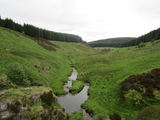
Friday 25 June 2021

Pennine Way Day 17 - 24 June 2021

Clennell Street to Kirk Yetholm
Walking 6.10am to 1.15pm
Distance walked 14 miles
Distance remaining 1 mile

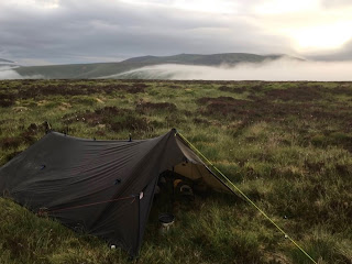
A very quiet and calm night, unlike in 2017 when I camped here in the windiest conditions ever. I was woken by a skylark singing at what I thought was 5.40 but it was 4.40. Still, I thought I might as well get going. There was low cloud outside which meant no views but, in a clear moment I got a photo of a cloud inversion. As I was packing up, two Spine Race runners went by and we had a brief chat. 


I got under way. There was no chance of going wrong, just follow the fence, sometimes in England, sometimes in Scotland. In fact, the fence doesn't really denote the border. 

When I reached the signpost for the detour to The Cheviot visibility was poor so I didn't go that way. It's about a mile each way and The Cheviot is an unimpressive lump by all accounts. This partly explains why I've got a mile left over above. I didn't see anyone until I got to Hen Hole Hut where were some tents and one person (two others had gone for water), a Spine Race checkpoint. By this time, the clouds and mist had cleared and I had good views for the rest of the morning. I'd never seen Hen Hole before as visibility was bad here in 2017. 

The ascent to The Schil was long but I was expecting it. 


I took the high level alternative towards KY (I took the low level on last time - more road walking and fewer views). It was worth it as the views were stupendous and far reaching although the ascent to White Law was punishing. 


Descending the to the road where both routes meet, there was a steep hill before cruising down to KY and the Border Hotel where I claimed my free half pint of beer and got a certificate of completion. I also treated myself to lunch, my only meal out. 

Me in 2021


Me in 1977

Wednesday 23 June 2021

Pennine Way Day 16 - 23 June 2021

Byrness to Clennell Street
Walking 5.40am to 4.20pm
Distance walked 14 miles (plus 1.5 miles for detour)
Distance remaining 15 miles

I woke early to see the midges swirling again. Fortunately, I'd slept with my head net on so I had a good night. I started getting ready at 4.45am and made tea. I should have covered it while it was brewing. I had to scoop loads of midges out before I could drink it. Those that were left were unlikely to cause me any harm. 


The steep ascent and final rock scramble out of Byrness got me on to Byrness Hill with the warning on the gate that there might be soldiers milling around and that there might be firing and pyrotechnics, but reassurance that live ammunition wasn't used. In fact, I saw no soldiers at all, unlike in 2017 when a spread out file of them in full battle dress emerged out of the mist and followed the PW for some distance. I simply took my place in the file. It was quite amusing. 


I made really good progress over the dry, springy ground. At Chew Green, the Roman camp, I stopped to brew coffee and a Spine Race runner came by. I took a photo and then he was off again. Not running though. When you've been going for nearly 250 miles it's more of a trot. Coming from the other direction was a fellow walking from Cape Wrath to The Lizard. 


There wasn't any sun and it was generally overcast and a little breezy. Perfect walking weather really. At Yearning Saddle refuge hut was another Spine Race checkpoint and not long after another runner appeared. I stepped off the path to let him go by. 


At Windy Gyle I stopped for lunch. I recalled my camp here in 1977. It was hot and late afternoon. I was parched but some kind people coming down gave me some orange squash which I put in a mu and carefully carried it up. As I was putting my tent up, a nosey sheep came by and knocked it over! A fine spot if the weather permits it as the views are superb. Darren and Dave appeared and stopped as well. I left first and headed for Clennell Street, a mile further on, where I spent a very windy night in 2017. I made a detour to Davidson's Linn, a twenty minute walk away to the east through some forest to a secluded valley. Here there is a neat waterfall and fast running stream. I drank a good amount of my remaining water, made tea and replenished my water from the stream to get me through the rest of today and tomorrow. 


I then returned to Clennell Street and pitched on the Scottish side of the fence. I didn't want to be on the English side this time as I might find a Spine Race runner tripping over a guy line in the night. 


Later this afternoon, two lady PW walkers appeared, Sandra and Ally, who I hadn't seen before. After chatting for a while, they went off to pitch not far off. 

I had an interesting supper. At the pitstop at Hornistead there was a part used bag of Huel, green Thai curry flavour. I took a couple of scoops and memorised the instructions. I ate it this evening. It was quite good and probably my healthiest meal so far. 

Pennine Way Day 15 - 22 June 2021

Bellingham to Byrness
Walking 9.40am to 7.30pm
Distance walked 16 miles
Distance remaining 29 miles

I had to wait until nine o'clock to retrieve my power pack from the site reception. I called first at the Village Bakery in Bellingham and bought two steak pies, two slices of Sly cake and two pieces of flapjack. Then a few items from the Co-op next door. I ate one of the pies for breakfast just across the road on a bench. Oh my, it was amazing. 


It was to be yet another warm, dry day. Not a lot to be said about the terrain for the first few miles. All dry underfoot and the path easy to follow. Plenty of sheep (but hardly any birdsong for some reason) and large open spaces with wide ranging views. Past Padon Hill as the forest is reached on the left, there was a very steep climb with some oozing mud of an unpleasant colour which I was careful to avoid stepping in. 

Reaching Brownrigg Head, I was passed by a Spine Race runner, she having run all the way from Edale. She didn't stop. I was glad to see that a rough path had been laid for the mile or so that was a nightmarish bog experience when I passed this way in 2017. Further along this path, much of the forest had been felled and replanted. It looked totally different from before.


Eventually, the path met the forest road leading to Byrness, a few miles away. It was tedious so I started listening to an audiobook on my phone. About a mile before Blakehopeburnhaugh I stopped for a breather before the final push to Byrness. Whilst sitting by the side of the road, I espies a young woman walking up the road. No pack and there's nothing for miles in the direction I'd come from and where she was going. I asked her where she was going. She was the medic for the Spine Race and was wandering up to see the route. I don't think any runners were due as they can all be tracked online. The last in the race were around Hawes and I was there about a week ago. They are very spread out. 

I stopped at the Race checkpoint at Blakehopeburnhaugh and cheekily asked the marshal if he had any water to spare. He had 100 litres and happily let me have two and also offered me a mug of tea which I didn't refuse. The checkpoint is being manned till Saturday. 

A mile further on I came to the forest wild camping spot I had in mind but it was totally unsuitable so I walked on. Not far on from there I found my spot, next to the footbridge before Byrness - and the river provides good water although I didn't need any. A vehicle track passes nearby and there's a house up on the edge of the forest but I'm screened from it by a belt of trees. A lady with children who walked by said she didn't think I'd have a problem. It's rather midgey though when the breeze drops. 


Monday 21 June 2021

Pennine Way Day 14 - 21 June 2021

Haughtongreen Bothy to Bellingham
Walking 7.30am to 2.10pm
Distance walked 11 miles
Distance remaining 45 miles

Woke up and the midges were swirling about inside and outside the tarp. Slept peacefully with my head net on all night. With the long grass I'd pitched on I actually had my most comfortable night of the trip. I packed quickly and repaired to the bothy to make tea away from the midges. As I left, it started to rain and this continued for much of the morning. 

After rejoining the PW from the bothy path, the walking was on a stony vehicle track for a little distance before it veered off on to a narrow grassy path into the forest, then emerging on to Haughton Common, a wide expanse of moorland. Absolutely no-one else about. Then into more forest and then rough pasture. 


At Hornistead Farm, I called in at the hikers' pitstop. This has been available for quite a few years. Seems that the family walked the Appalachian Trail in the US and were so impressed with the trail magic given to hikers by so called trail angels that they established their own for PW hikers. Hot and cold drinks and snacks are there for the taking. It is unmanned and donations can be given. There is a loo and shower and camping is available. A really great resource which would be much missed if it disappeared.

The rain having stopped, the last couple of miles were field and road walking to the Camping and Caravanning Club site on the edge of Bellingham. Excellent facilities. I stayed here on my PW walk in 2017. My power pack is being charged overnight in the office but it doesn't open till nine in the morning but tomorrow is only a fifteen mile day. 

Sunday 20 June 2021

Pennine Way Day 13 - 20 June 2021

Knarsdale to Haughtongreen Bothy
Walking 5.25am (again) to 6.10pm
Distance walked 24 miles
Distance remaining 56 miles

Was planning a longer distance today. The morning started a little misty on the surrounding hill tops. The path went through or alongside some open access areas. Plenty of curlew and lapwing wheeling about, uttering cries to keep me away from their nests. A few very vocal skylarks as well. I've seen no prey at all so far. I think merlin can be seen in this part of the country. Yesterday and before then there were golden plover. 


Blenkinsopp Common was an inhospitable expanse. I went astray from the path here as it was so indistinct at times. Certainly not an area for trying to find somewhere to camp. 

I had no need to divert into Greenhead. In the nine miles I'd walked I saw no-one. The path went through Haltwhistle Golf Course and, as luck would have it, within fifty yards of the club house where I was able to replenish my water, it being open. Crossing the railway and passing by what is left of Thirlwall Castle, I started the long ascent up to Hadrian's Wall. The Wall Trail is a national trail from the Solway Firth to Newcastle and the Pennine Way follows it for some eight miles and is hard work with its roller coaster ups and downs. I've walked this eight mile stretch three times altogether I had no wish to do it again, especially in today's warm weather. Therefore, I devised a route which followed a lane and tracks south of the wall until Caw Gap where a road took me north of the wall and then a track and path to meet the PW. The road part was particularly tedious but there were no really serious inclines. 


After following the PW for just over a mile, I took a side path to Haughtongreen bothy, one that I've wished to visit for some time. The interior is not to the standard of Greg's Hut. I don't know how much it's used but, being closer to civilisation, it attracts some less desirable visitors. It didn't feel welcoming. I gave it a good sweep and moved some empty cans out of the main room. I'm camping nearby. 

The midges are very bad; the air is thick with them. It's rained a little but that hasn't deterred them. 


Saturday 19 June 2021

Pennine Way Day 12 - 19 June 2021

Greg's Hut to Knarsdale
Walking 5.25am to 5.45pm
Distance walked 18 miles
Distance remaining 80 miles

Woke really early to see the sunrise throwing an orange glow on the side of the tarp. Got going quickly to start the long walk down to Garrigill, just over six miles. I was caught up by the two Yorkshiremen, who are Darren and Dave from Rochdale so, actually are Lancastrians but they went on ahead. About two miles of the track has been resurfaced since I last passed this way and made for a better pace of walking. 

At Garrigill (where the shop is still open (although I was too early for it) but the pub remains closed), I checked out the up to date information for camping behind the village hall (£7 donation with loos open 24 hours). On then to Alston. On the way I met Adam Jelfs, walking from John o'Groats to Land's End, posting to Facebook now and then. I gave him my blog address. In Alston, I bought some Isle of Mull cheddar at the deli  Across the road were Darren and Dave sitting at the market cross. They kindly looked after my pack while I did a resupply at the Co-op. They've booked into a B&B because of the dearth of camping options in Alston. 

I then left them and walked out of Alston, thinking of a possible wild camp at Whitley Roman Camp, although it was still only about 12.30pm. That's a problem with an early start to the day.  After a couple of miles I stopped for lunch. In fact, I stopped for about an hour. Whilst there, a walker came by and we talked. I don't know his name but he was walking from Oxford to Edinburgh. An interesting fellow, in his twenties, Swiss but has grown up in the UK. He said he had left Keld this morning and walks all the daylight hours. Looking up the mileage later, Keld was 66 miles away so that couldn't be right. 


I passed by the fort. Whilst it might be suitable for a late wild camp, it's in a working farm and it was still only mid-afternoon. I topped up my water at a tap on the side of Yew Tree Chapel in Slaggyford which I knew of. Near Knarsdale, I was sitting with my back against a gate taking a quick break. I had to move to let a lady through with a dog. Falling into conversation, she and her husband farm nearby and she gave me permission to camp a couple of fields further on. I had intended to walk further but gratefully accepted her offer. 

Friday 18 June 2021

Pennine Way Day 11 - 18 June 2021

High Cup to Greg's Hut
Walking 8.45am to 6.10pm
Distance walked 14 miles
Distance remaining 98 miles

Came to with a start. Looked at my watch - 8.50 - realised then it was only 7.45. Still, late enough. Got going quickly. I had the whole wide area of High Cup Nick to myself and it was glorious. Began the four mile descent to Dufton. At the Post Box Pantry tearoom, I bought flapjacks but went back in and ordered a pot of tea, scone, jam and cream. I had time to spare and it was a lovely day again. 


Then followed the long approach via green lanes, tree lined paths and then a half mile walked track before entering open access land. I stopped for lunch at just over three miles, the views west towards the Lake District being clear. Continuing to ascend, I reached Knock Old Man, from which I could see clearly the radio station at Great Dun Fell over a mile away. Usually, for me, it's hidden in fog and rain. Next a level walk, descent and then ascent to walk next to the radio station. Here I stopped to chat to a couple out walking for the day, the only people I met after Dufton. Descent and then ascent to Little Dun Fell and then a further descent and ascent to Cross Fell, such a vast high plateau and no-one else around. 


On the other side, on the way down, it was boggy and got feet a bit wet but usually far worse. On joining the bridleway running east west it was half a mile to Greg's Hut. Inside were the two Yorkshiremen, intending to overnight inside. Someone had left sleeping bags there with a note saying please leave for a family with five children coming tonight! They duly arrived, presumably to sleep in the bothy. There's been some noise but all is quiet now. I'm very glad I'm sleeping outside. 


Pennine Way Day 10 - 17 June 2021

Middleton in Teesdale to High Cup
Walking 8.50am to 7.00pm
Distance walked 17 miles
Distance remaining 112 miles

I'd planned a later start with a view to buying one or two of the local butcher's celebrated pies. However, as I walked in that direction, I visualised them getting mangled in my pack and I didn't really fancy a meat pie for breakfast. So, as I came to the PW sign, I turned off. 

The path followed alongside the Tees for several miles, sometimes above it and sometimes at the same level, passing through wild flower meadows and narrow wooded paths, all quite delightful.


I saw nobody else until the path approached Low Force, quite a tourist attraction, although not nearly as impressive as High Force, a mile further on. Once I'd left the sightseers behind, I found some shade beneath some young trees by the river to brew a late coffee. The outlook was marred somewhat by the working stone quarry on the other side. 


Walking on, I came to Sayer Hill Farm, where camping is available. I went up to the house and was met, not by the owner, Hayley, but Hayley's mum, Jo. I was wanting to get up to date information about the camping and facilities for the Backpackers Club directory as the entry hadn't been updated since 2016. The charge is now £5. I was offered a welcome mug of tea and we chatted for a while before I had to be on my way. 

A couple of miles on and the high banks of the Tees began to close in. The path became rocky although the rocks below Falcon Clints were potential ankle breakers and required extreme care. Reaching the base of Cauldron Snout, I stowed my poles so as to have both hands free for the strenuous scramble upwards alongside the rushing torrent. 


At the top, and below the dam of Cow Green Reservoir, I followed the stony vehicle track for about two miles of gradual ascent before the PW left it for a grassy path with, after a while, Maize Beck appearing on the left. After a further two miles I reached High Cup which comes into view right at the last minute. It really is stunning. I pitched but unfortunately not getting the view from my doorway due to the wind.