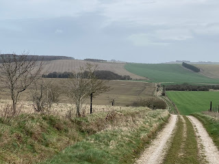
With a few days to spare and having to withdraw from the TGO Challenge in May, I decided to walk a further stretch of the Seven Shires Way in late March. I finished the last part in October 2020 not far from Thame. To resume from there isn't that easy using public transport and, if I walked for a few days, would involve walking alongside the Thames through Reading and I was quite happy to avoid this. Therefore, I got the train to Goring & Streatley with 85 miles or so to walk over five days.
On leaving the train, I bought a few things at the nearby Tesco and then went in search of the SSW. The first stretch follows the course of the Thames Path National Trail and then leaving it at Moulsford. A short road walk led me to a restricted byway alongside Moulsford Downs and then to the Ridgeway National Trail which I followed for several miles. I had reckoned on camping at Scutchamer Knob, a belt of trees shown on the map. There was a car park there with a couple of vehicles parked but it was fine. I obviously didn't take any photos this first day. It rained on and off.
Next morning I continued along the Ridgeway for a couple of miles and then taking a track to the left named on the map as Old Street. Reaching the village of Farnborough, I made use of a water tap I spied from the road at Upper Farm. The paths and tracks I walked were all easy and totally deserted with a feeling of remoteness.
 |
| An interesting field and hedge formation |
Through Fawley and into real horse country along straight tracks and a long stretch of road beside Eastmanton Down. Past Sevenbarrows House, a large equestrian place, I came across a large belt of woodland. I was looking for a camping spot but it was well fenced in so I continued walking. At SU306839 I saw a youngish plantation not marked on the map and only a hundred yards away. Perfect.
Crossing the B4000, I diverted from the SSW, taking the single track road to the south of Ashdown House (NT) and rejoining it at Swinley Down. I met the Ridgeway again at SU263865 where there was a water tap and, a short distance away, saw someone had set up home. A bit unsightly.
I left the Ridgeway at SU248823 and headed for a delightful grassy path through a dry valley
Next morning, I headed for Coleshill where my route took me northwards across a few fields and then a longish road walk where I turned onto a farm road at Snowswick Cottages leading to Broadleaze Farm. At Buscot (NT) I found a village tap that actually worked and replenished my water. Here it came on to rain quite steadily.
From here I went on to rejoin the Thames Path and followed this to Kelmscott. William Morris is buried in the churchyard.
 |
| Kelmscott church |
Coming into Holwell, a house was being renovated and I went in and made use of a water tap. I was now on familiar ground on the D'Arcy Dalton Way, passing through Westwell, Little Barrington and Great Barrington. Here I stopped in the rain to talk with a Cotswolds warden. I found a useful water tap at Great Barrington (SP210138).
Rain came on with a vengeance but I found a reasonably sheltered spot for lunch at Miletree Clump. The muddiest length of path was at SP231165, a steep uphill that had been churned up by 4WDs. It was a struggle. The path then went alongside the former Little Rissington airfield and then into Fifiled. Whenever I pass through here, I check an unobtrusive water tap just opposite the gate into the church. The tap still works.
 |
| Fifield water tap |
I was away early next morning on familiar paths. I was treated to a rainbow over Bledington.
Through Kingham and then a long bridleway which was flooded in places. There wasn't always sufficient grass verge. Here's a stretch where I had to wade very carefully to avoid the water filling my boots.


