Sunday, 30 December 2012
Scotland End to End
A minor bout of 'flu between Christmas and New Year was an opportunity to slump in front of the TV and watch the two part BBC Scotland Adventure Show featuring Cameron McNeish covering the newly opened Goretex Scottish National Trail. The Trail has as its starting point the Border Hotel at Kirk Yetholm (being the start or end of the Pennine Way) and follows a meandering route north to Edinburgh, west to Falkirk and then generally northwards to Cape Wrath, a total distance of 470 miles. Along the way, Cameron meets various people who have something relevant to say about the landscape or a feature of it which adds to the interest. Needless, to say, the photography is stunning and really does justice to this amazing part of the world. The second part of the programme showed Scotland at its remote and wildest best. There was a brief switch at the end to the opening ceremony at the end of October 2012 when the Trail was officially opened by Scotland's First Minister, Alex Salmond. It is clearly hoped that the Trail will equal the West Highland Way in attracting visitors and their spending power to this part of Scotland. It will be interesting to see to what extent Mr Salmond and others in high places oppose the current plans for the Ministry of Defence to close off Cape Wrath (most of which it already owns). This will presumably have the effect of cutting off the final section of the Trail and force out of business the Ozone Cafe. There is a possibility of a community buy out and it is to be hoped that this is successful, otherwise this beautiful corner of Scotland will be closed to public access.

Wednesday, 24 October 2012
Review - Berghaus Ardennes softshell
I was sent this softshell jacket for review and I liked it very much. It has been available for maybe a year or so. There are a lot of softshells on the market. Is this one any better than any of the others? I really don't know but Berghaus is a well known name and British (despite the Germanic sound of the name).

I'm of maybe just under average height (5ft 6ins) with perhaps 38in chest; the size medium was just right. It was a good fit. The colour was a two-tone grey (dark and light) and quite attractive. I felt that the white zips were a bit on the stark side but got used to it. I wore it during a weekend that wasn't too cold. The fleece lining was comfortable and so were the elasticated cuffs. The hem is adjustable if you feel the need to keep cold weather out from below.
It is treated with a Durable Water Repellent (DWR) finish so should shed at least light rain. It's also windproof and breathable. There is a full length zip and also two zipped side pockets, mesh lined; there's no chest pocket. Inside are two large mesh pockets.
The jacket weighs 540g in size medium. Using layering, I don't see why it shouldn't be suitable for year round use. The RRP is £90.00; a variant with a hood is also available for £100.00. There's not much not to like. It does the job and well.
Thursday, 18 October 2012
Terra Nova Voyager Ultra 2

If Terra Nova will lend me one for a weekend I'll happily try it out and post a review.
Monday, 15 October 2012
Backpackers Somerset weekend
Well, it was a very select three of us who turned up for this, including Dave the organiser. I arrived at the farm site at Priddy late Friday afternoon after battling my way through the traffic in Bath. Lovely city, heavy traffic. In the evening we spend some time in the Hunters Lodge pub which does an excellent pint of Butcombe (and Cheddar Ales Potholer), gravity fed, I believe. The food menu was interesting. I wasn't eating there but the menu listed some basic items, all priced at £4.00!


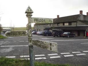
Next day, the other two were walking off somewhere, returning to base later in the day. I fancied a wild camp somewhere so set off alone after breakfast. From the site, I went across fields to Priddy village although there didn't seem much to it. I joined the West Mendip Way and followed this westwards to a bridleway following contour lines above Draycott, seeing no point in dropping down to the village, only to climb up again a little further along. The path then skirted Cheddar. The views here were wide ranging with Cheddar Reservoir in the foreground and the Somerset Levels spread out around and a glimpse of the Bristol Channel in the far distance.


My path then climbed up close to Cheddar Gorge and then wound down through woodland to the road at Black Rock. I last went this way in 2009 on en route to John o'Groats. The West Mendip Way then heads towards the village of Shipham although I left it in Rowberrow Warren, heading northwards to pick up the Limestone Link in Dolebury Warren. Mud was here aplenty but it was a nice route to follow. The rocks of Burrington Combe came into view. This rocky gorge was the inspiration for the hymn "Rock of Ages" by Augustus Toplady. It was by now late afternoon and I was able to collect water from a stream and I looked for somewhere secluded to pitch for the night. I came across a lad, his girlfriend and a dog with a tarp pitched. It was the girlfriend's first night under a tarp. I wondered how she'd feel about it in the morning.
I found a nice spot about half a mile further on under some small trees, separated from the path by a belt of ferns, well out of sight. It had been a lovely sunny day, apart from a brief shower in the morning. All was very quiet here, even the wildlife was almost silent.


Next morning, I was off by 8 o'clock. It was only when I reached open ground that I realised that there had been quite a frost overnight. My route took me eastwards to Compton Martin. Not far from here, I picked up signs publicising the Chew Valley Arts Trail and I found Venue 19 at Shortcombe Farm, just outside West Harptree. There was an exhibition of sculpture by Jeremy Palmer (and paintings by his wife, Pauline). I was made very welcome.

A little further on, the views across to Blagdon Lake were beautiful.


On the B3135 road, going into woodland, I picked up the Monarch's Way, a 615 mile route loosely based on Charles II's route of escape in 1651 after losing the Battle of Worcester. Parts of it were very muddy. From here, I headed back to Priddy, following a path across the Priddy Mineries, a nature reserve, an area used for lead mining in centuries past (in fact, until 1908).
The weather today was sunny with clear blue skies. Once again, the weatherman got it wrong. Yesterday's walk was about 15 miles and today was 10 miles.
Tuesday, 9 October 2012
Book review - Grizzly Bears and Razor Clams by Chris Townsend
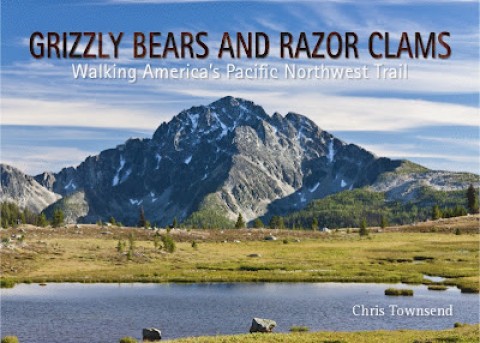
What an
odd title! Also, an unusual format, landscape rather than portrait.
The book is paperback and provides an excellent taster of the quite
new Pacific Northwest Trail in the USA. This is trail that was long
in the making, the result of many years pioneering work by Ron
Strickland, who wrote his own account in Pathfinder: Blazing a New
Wilderness Trail in Modern America, but they are very different
books. The PNT starts in Glacier National Park in Montana just south
of the Canadian border and ends on the Pacific coast near Seattle,
some 1200 miles.
Townsend's
book is an account of his solo hike along the PNT. Each of the seven
chapters covers a section of the trail. There is a heading comprising
a chapter name, the start and finish points of the section, the dates
and mileage and also a very helpful map showing the section with his
route and the PNT guidebook route. He didn't follow the guidebook
route all the time for various reasons. Whilst reading, I often found
myself referring back to the maps.
He writes
well and manages to make this far more than the "I got up early
..." type of account and my interest was sustained throughout. I
wanted to be there doing it as well. It wasn't an easy walk though,
far from it. There was a navigable trail along some of the route but
in some parts he was bushwacking and struggling to discern a path. It
was a tough walk and to complete it, as he did, was quite an
achievement. At other times, though, there were road sections that
were tedious and an e-reader came in useful!
The book
is generously illustrated with colour photographs taken by the author
as he went and complement the text very well.
At the
back of the book following the account of the walk are appendices
setting out some statistics, navigation, food (as resupply was
something that had to be well planned in advance), equipment and
clothing, finishing with a short section on photography. He took
1,868 photographs in the course of the walk.
I enjoyed
this book. It is well written and an engrossing read. It made me want
to be on the next flight across the Atlantic!
Peak District
Frank, Sean and I met up in Matlock. Our night's camp was pre-booked at the Duke William pub, a good pitch apart from the very loud church clock nearby. Still, the pub was welcoming, the beer was good and so was the food.

Next morning we set off north along the Derwent Valley Heritage Way out of Matlock for about three miles up to Rowsley where we stopped for coffee and a snack at Caudwells Mill.

It would have been nice to have spent more time here but we had to get on. We left Rowsley along a yellow (on the map) road northwards which turned into an enclosed track and then into woodland at Bouns Corner, across the top of Haddon Park and then down to the A6 road, taking the footpath across the road from Haddon Hall to Alport. From there, into Youlgrave and a refreshment stop at The George. We probably stopped too long there!
From Youlgrave, we joined the Limestone Way and followed it for a few miles into Winster where we pitched behind The Miners Standard. The last time I camped here was February 2011 when we were hit by heavy snow - see http://litehikersblog.blogspot.co.uk/search?q=standard. Next morning, we continued along the Limestone Way back into Matlock. An excellent, but ridiculously inexpensive, full English was had at the cafe adjoining The Railway pub.


Next morning we set off north along the Derwent Valley Heritage Way out of Matlock for about three miles up to Rowsley where we stopped for coffee and a snack at Caudwells Mill.

It would have been nice to have spent more time here but we had to get on. We left Rowsley along a yellow (on the map) road northwards which turned into an enclosed track and then into woodland at Bouns Corner, across the top of Haddon Park and then down to the A6 road, taking the footpath across the road from Haddon Hall to Alport. From there, into Youlgrave and a refreshment stop at The George. We probably stopped too long there!
From Youlgrave, we joined the Limestone Way and followed it for a few miles into Winster where we pitched behind The Miners Standard. The last time I camped here was February 2011 when we were hit by heavy snow - see http://litehikersblog.blogspot.co.uk/search?q=standard. Next morning, we continued along the Limestone Way back into Matlock. An excellent, but ridiculously inexpensive, full English was had at the cafe adjoining The Railway pub.

Monday, 24 September 2012
Backpackers Exmoor weekend
The weekend didn't get off to a good start, to say the least. My usual packing list was composed ages ago and I've been using a tarp for the last ten years or so. I thought this time I'd take my new £200 off Laser Comp. When I was the best part of thirty miles from home it suddenly dawned on me that I'd left the tent pole at home. I turned around and went back to get it. Absolute pain. I then hit the M5 around Bristol at 5.15pm, the worst possible time. It took ninety minutes to get clear of it. As a result, I didn't get to Malmsmead (between Porlock and Lynton) until 8 o'clock, by which time it was dark. I took the wrong road off the main road down to Malmsmead, having to negotiate a hairpin bend on the single track land and then Robber's Bridge, with a stone sided wall either side. I just breathed in and hoped for the best.
I didn't see any of the other attendees until the next morning. There were just five of us, a very select bunch. I fancied a day out walking on my own on the Saturday so set off south towards Badgworthy Water across the river from Cloud Farm. It was a perfect morning.

Walking east of Badgworthy Hill, I passed by Larkbarrow and then on to the lane by Alderman's Barrow. The Exmoor Hunt was much in evidence, milling around me at times. They were pursuing a stag, I was told. At Larbarrow Corner, I went westwards on the Macmillan Way West by Warren Farm to Prayway Head and then along the B3223 until I veered off east on a bridleway at SS764423 across moorland where I stopped for a snack at Hoccombe Water. I then headed back to Badgworthy Water and Malmsmead. A really nice day.
Saturday evening was spent at the Staghunters Inn at Brendon. I didn't eat there but others did and said the food was good. Not fancy but good wholesome fare, e.g. liver, venison, etc.
 |
| A scene from Lorna Doone |
Sunday's walk was back down to Badgworthy Water (really lovely), towards Larkbarrow and then up to the hamlet of Oare. At this point, I was with Andrew (probably in his late 60s) and Ian, aged 73. Andrew was navigating and led us the wrong side of a field boundary. We ended up having to negotiate a double barbed wire fence, scrambling up a steep bank and then jumping over another fence to tumble down the other side. It didn't end there! We found ourselves in the garden of Oare Manor House. Walking down the driveway, there were a pair of electric gates separating us from the road. Andrew was trying to give Ian a stirrup lift over but they were too high ( I don't know how the last man would have got over). Anyway, I saw a way out, up a rock wall and over a fence into the churchyard and that's where we went. All very unorthodox.
Subscribe to:
Posts (Atom)


