Friday, 8 May 2009

Day 34 Friday - Marsden to Hebden Bridge

Walking 7.25am to 4.00pm
Distance walked today 14 miles
Total distance walked 490 miles
Distance left 562 miles

The landlord of the Carriage House had helpfully pointed out a short cut across Marsden Moor over the road to get to the Pennine Way, avoiding road walking. My planned route would have taken me through Marsden and then a remote moorland route to Hebden Bridge. It struck me that it would make sense to make straight for the Pennine Way. I didn't need anything in Marsden and the Pennine Way would be easy enough to follow.

The day started clear but quite breezy and got windier as I gained height. There was moorland for miles around me and as far as I could see. I felt very small. There was no-one else about. I saw signs for the Standedge Trail, the Oldham Way and the Rochdale Way. In fact, the Rochdale Way shared the same route as the Pennine Way for much of this morning. The PW took me over White Hill (nothing there but a white-painted trig point)and across a frantically busy M62.

White Hill

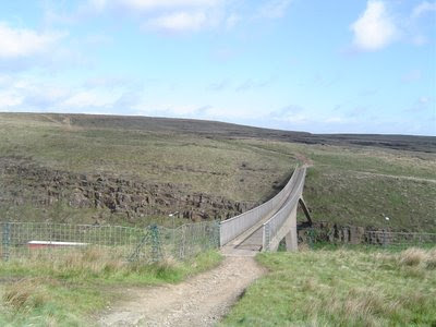
Heading towards the M62

Crossing the footbridge over it was quite hairy as the cutting was like going across a wind tunnel. It was noisy and I struggled to stay on my feet.

The wind hardly lessened even when I reached the other side. I was still trying to listen to Radio 4 (through earplugs) at this stage but gave up as the wind drowned it out.

As I stopped for a snack break, another walker caught me up. This was Barry from Longden End nearby on one of his regular circular walks. I enjoyed his company for the next mile along Blackstone Edge. He left me at the Aiggin Stone to head home via the Rochdale Way. I then continued on down to The White House pub (which didn't open until midday). At this point the howling wind turned into howling wind with rain. As the Pennine Way now went up higher to skirt the edge of several reservoirs, I felt that a lower level route might be preferrable. I went alongside Blackstone Edge and Light Hazzles Reservoirs but the rain (and sometimes, hail) came at me horizontally and I had difficulty staying on course. I wasn't here to walk the Pennine Way so had no problem in deciding to get off it.

Alongside Warland Reservoir, I took a track down into the hamlet of Warland. Immediately I began to lose height, the sun started to come out and the rain and wind disappeared - amazing. In Warland I stopped at The Bird I'th Hand for lunch as I had little else with me to eat. I then joined the towpath of the Rochdale Canal a hundred yards away and had an easy and enjoyable walk for about six miles into Hebden Bridge passing by Walsden and Todmorden.

In Hebden Bridge, my cousin John met me as arranged and we drove to his home in Bolton. Tricia, his wife has cooked a lovely meal. Daughters, Jules (with Paul and baby Ava) and Vicky and boyfriend Ben were keen to hear first-hand about the walk but generally glad there were not doing it themselves!

Day 33 Thursday - Langsett to Marsden

Walking 7.50am to 5.30pm
Distance walked today 16 miles
Total distance walked 476 miles
Distance left 576 miles

The day was forecast to be dry which was nice after all the rain yesterday. After a short distance on the A628, I took a footpath to join the Trans-Pennine Trail, a route which appears to cross the country from the east coast north-east of Hull and which goes west to Liverpool and up to Southport. At this point, it was along a disused railway track but it also uses towpaths and other rights of way.

I followed it for about three miles to Dunford Bridge where I went up to the dam at Winscar Reservoir and was then on the Pennine Cycleway.
Winscar Reservoir
This took me round Harden Clough along a lane south of some coniferous woodland.

Snittlegate SE149043
After a mile and a half, I left the Pennine Cycleway to go west along a bridleway by Crossley's Plantation. This took me down towards Brownhill Reservoir just before the village of Holme. However, some major works were going on and the path was diverted. I backtracked and took a path towards Yateholme Reservoir and then a path through Holme Woods which then dropped steeply down, over a stream bridge and up to a track which took me into Holme. I took the Kirklees Way out of Holme to Digley Reservoir and followed this up to the A635 and on to the Pennine Way at Wessenden Head.

Looking back to Holme

Wessenden Head

A little way past Wessenden Reservoir, I caught up with a couple from Lincoln who had started walking the Pennine Way yesterday (the day when it hadn't stopped raining). We walked together for a couple of miles (collecting another PW walker along the way) and I then left them to go alongside Redbrook Reservoir to find my campsite behind the Carriage House pub (on the A62 two miles south-west of Marsden and just off the Pennine Way). Globe Farm nearby no longer does camping. The beer's good (Black Sheep) and they specialise in Turkish cuisine. I was weak-willed. Despite having a meal to eat under the tarp, here I am in the pub having had Turkish lamb, rice and salad followed by jam rolypoly and custard! Oh well, I'll walk it off tomorrow. This is a good place. When they found out I was walking for charity, my £5.00 camping charge came back so that will go to my MS charity.

Thursday, 7 May 2009

Day 32 Wednesday - North Lees, nr. Bamford to Langsett

Walking 8.10am to 5.50pm
Distance walked today 18 miles
Total distance walked 460
Distance left 592

It rained all night and continued as I packed up. It was also quite misty and as my plan had been to climb up to Stanage Edge and Derwent Edge before dropping down to Ladybower Reservoir, I thought maybe a lower level route might be better.

Bridge at North Lees NT
Therefore, I took field paths and a lane (most unsuitable for motor vehicles) down to Bamford Station and followed the Derwent Valley Heritage Way through Thornhill, going over the dam at the southern end of the reservoir. Following the road round to Ashopton, I took the trail alongside the reservoir, continuing beside the Derwent and then the Howden reservoirs.


I thought then to save half a mile or so and took the path up to Howden Clough as this joined the bridleway I wanted near the trig point at Margery Hill. Things didn't go altogether to plan as, after a mile or so the path just disappeared. This was real Dark Peak open moorland. Devoid of people and quite bleak. I wasn't too concerned as the route of the path ran parallel to a track on the ridge just to the east going in he same direction. After a bit of floundering about, however, I located the path and got up to the ridge path. Following this for a while, I found the trig point and was then able to go on and get on to the bridleway which, after three miles, led down to Langsett Reservoir and a very pleasant high level walk through woodland along part of the Barnsley Boundary Walk - I think I must be in Yorkshire.

From here, I made my way for a mile in the direction of Thurlstone to a campsite at Paw Hill Farm. It's very basic, just a cold tap and a loo. The site is extremely exposed and the tarp is being buffeted about and is very noisy because of it - I hope it's still over me in the morning. I shall use earplugs tonight.

Wednesday, 6 May 2009

Day 31 Tuesday - Baslow to North Lees nr Bamford

Walking 8.30am to 3.35pm
Distance walked today 10 miles
Total distance walked 442
Distance left 610

A short day today, partly on account of available overnight stops and the need to replenish lunches for the next couple of days.

The nice lady at last night's stop kindly offered to charge my phone. I packed up in the light rain this morning and cut through the farmyard to join the nearby footpath below Gardom's Edge leading to the A621. Crossing this, I climbed up through some woodland alongside a private house with amazing landscaped gardens.

I climbed up through the woodland in the direction of Wellington's Monument (which I didn't actually see) to join the bridleway along the exposed Baslow Edge, continuing along Curbar Edge and Froggatt Edge.


Curbar Edge

To avoid walking along the A625 at this point, I followed paths through woodland (marked on the map as The Haywood) and then went back to the A625 for a hundred yards to enter the National Trust Longshaw Estate along a clear track. After a mile or so, I came to an NT tearoom and shop and had a pot of tea and some tuna and mayo sandwiches for lunch - very nice.


Burbage Brook

Over the road, I took the path through woodland signposted Burbage Brook and, reaching the A6187 at Toad's Mouth, I took the path down to Mitchell Field Farm and then headed down into Hathersage. On the way, the right of way through the grounds of a sizeable house. The gate is probably the only one I'll encounter that opens at the press of a button.

Food having been bought, I went off to find North Lees Campsite, operated by Peak District National Park. It's a sizeable site and I thought I had it to myself but, on an exploratory walk around, I discovered a small tent tucked away behind a wall.

North Lees campsite

The loo and showers are very clean and I'm told that the site is open all year round. I'm very impressed.

Tuesday, 5 May 2009

Day 30 Monday - Alstonefield to Baslow

Walking 7.15am to 6.40pm
Distance walked today 20 miles
Total distance walked 432 miles
Distance left 620 miles

Vinnie and I walked together for the first two hours or so. Leaving Alstonefield along the lane by the YH camping barn, we dropped back down to Dovedale.

After about half a mile, we forked right up Biggin Dale.
and into the village of Biggin. By the Waterloo Inn, Vinnie went off to join the Pennine Bridleway nearby. I continued on through the village, crossing the A515 and followed the track road to the crossroads north of Mountain Ash Farm. Turning left, I followed the lane to the A5012. Before I reached it, I could hear a growing rumbling sound and, as I got closer, I saw a field with marquees and a large number of motorbikes, many of them choppers. I stopped and asked one of the departing motorcyclists what it was. He said it was an annual gathering (I didn't quite catch the name due to the sound of his revving bike) which attracts 400-500 motorcyclists from the UK and Europe. It was just finishing.

Across the main road, I took the path down into Gratton Dale, following this to the lane at Dale End. Then taking the path by Lowfields Far, I followed field paths into Youlgrave. Unfortunately, it being Bank Holiday Monday, all the shops (such as they were) were shut.

I left Youlgrave by the road opposite the church (noting for future reference that Church Farm offers simple camping facilities). Crossing several fields, there a clear view of Haddon Hall ahead.

Over the A6, I followed the path, road and then track up into Manners Wood and then down into the estate village of Edensor. From above the village was a superb view of Chatsworth House.


I was hoping I might just get to the tearoom in Edensor before it shut but it doesn't open on Mondays.

I followed the main path leading to Chatsworth House. There was a steady stream of visitors leaving. I headed for the woodland behind the house, following a clear route through it, eventually reaching the Eric Byne Campsite (200 yards from the Robin Hood pub). I'm the only one here.

Monday, 4 May 2009

Day 29 Sunday - Uttoxeter to Alstonefield

Walking 8.15am to 6.00pm
Distance walked today 17 miles
Total distance walked 412 miles
Distance left 640 miles

There was some early morning rain but this had stopped by the time Gayle and I left the house. We drove to Uttoxeter station and left her car there. We then found our way out of the town via the Staffordshire Way, crossing some fields and then under the A50 dual-carriageway. The path at times wasn't particularly good, one farmer having recently ploughed a field, leaving little or no margin at the side for a path.

We followed the Way towards Rocester with the River Dove meandering off to our left, although we came right next to it as we reached Rocester. Here, we left the Staffordshire Way (which went off north west) and joined the Limestone Way which followed field paths before dropping down to the Dove, continuing to Ellastone. We had been looking forward to a drink at the Duncombe Arms in Ellastone but were amazed to find that it doesn't open at Sunday lunchtimes. We were both hungry by this time so went across the road and ate our lunches in a bus shelter - very sad!

Gayle then headed back to her car and I pressed on, picking up the Limestone Way again. It wasn't well waymarked as such very well so close attention to the map was necessary. I only lost the trail once.

Approaching Thorpe
The limestone hills of the White Peak came into view and it seemed no time at all before I was dropping down to Coldwall Bridge and climbing up the other side into the village of Thorpe - real Peak District. On the way into the village, I came across this marvellous car. A Frazer Nash, I think.

I stopped at a seat by the church to remove a stone from my boot and saw Vinnie! He'd walked from Uttoxeter as well on the same route as me but a little behind.

He was heading for a campsite at Tissington but I persuaded him to come with me as I was going up Dovedale. He'd never heard of it but I felt that he couldn't visit the Peak District without seeing it, even though, it being Sunday, it would be busy, as it proved to be.

We left the trail at the village of Milldale and took the lane up to Alstonefield where we camped on the site adjacent to the Youth Hostel camping barn.

We spent the evening in The George, discussing tomorrow's route and in pleasant conversation with Brian and Tess from Rugby who were up camping for the weekend.

Saturday, 2 May 2009

Day 28 Saturday - Rugeley to Uttoxeter

Walking 10.40am to 5.30pm
Distance walked today 12 miles
Total distance walked 395 miles
Distance left 657 miles

It's good to be back on course. I've had a very busy day or so, staying with a lady whose husband is away for a while (in fact, I'm married to her)!

I've bought a new pair of boots as a backup, my other spares having given up the ghost a week ago - Alt-Bergs again, exactly the same as I'm wearing now, except that I've gone for a wider fitting. I've also, with a little persuasion, invested in a new backpack, an Osprey Ariel 65. Chris at Outdoor Traders at Abingdon (15% discount to Backpackers Club members) spent a lot of time customising it to fit properly and I think it will be good. The pack I've been using the last three weeks is getting on for twenty years old and, I realised is made for someone with a longer back than I have. The new one is adjusted to my back length and should stay tucked in to the small of my back. That's the idea, anyway.

I was dropped off at Banbury station this morning and made my way back to Rugeley Trent Valley Station. By arrangement, Gayle was waiting on the platform, having left her car at Uttoxeter station and caught the train down. The idea was that we would walk by my route to Uttoxeter.

We walked a short distance along the Trent & Mersey Canal before leaving it to head north east to the village of Colton, following the Staffordshire Way (as we did for most of the day), across the head of Blithfield Reservoir and into Abbots Bromley, where we popped into The Goat's Head for their Black Sheep bitter. They have a beer festival tomorrow with sixteen real ales and an appearance by the Abbots Bromley Horn Dancers. Our route then took us through Bagot's Park (which seemed just like more farmland, not a park at all). It was then a straightforward walk for three miles or so along field paths into Uttoxeter, then by car to Gayle's home. We've had a meal and plan to walk on towards the Peak District tomorrow.